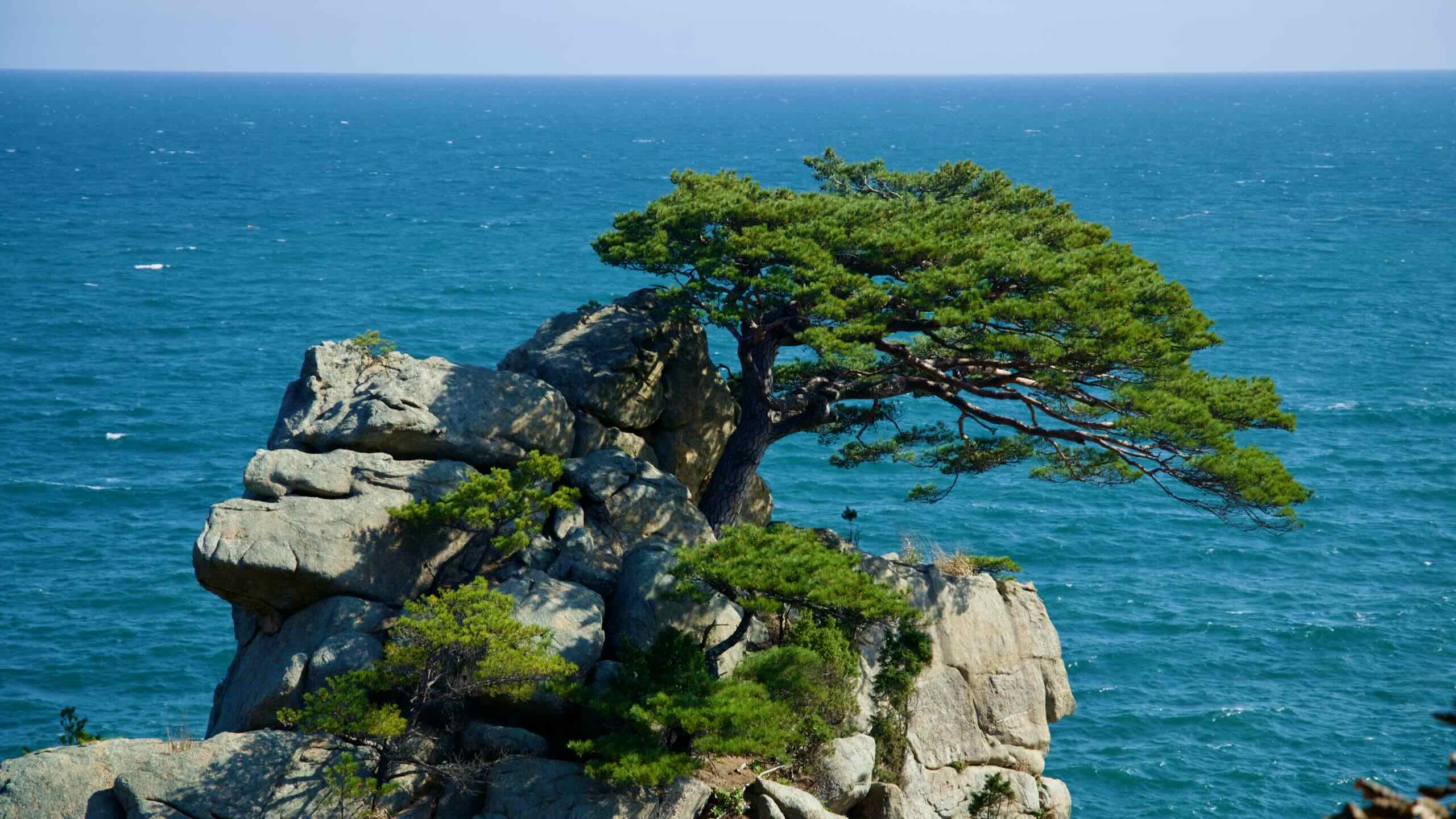
Hajodae (하조대; map) is collection of rocky cliffs that jut out from Yangyang’s coastline. Designated as one of the county’s 8 Scenic Views, South Korea features Hajodae in its National Anthem video with a shot of pine tree and pavilion on top of Hajodae’s wave-battered cliffs.
Legend has it, because of its natural beauty, Hajodae will irrevocably transform all who visit and view its craggy cliffs, rocky islands, and dense pine forest.
Hajodae also holds a few other key attractions, including a glass-bottom observatory, ancient pavilion, and a famous beach.
Let’s learn more.
The Name
The name Hajodae comes from the family names of Ha Ryun (하륜; 1348 ~ 1416) and Jo Jun (조준; 1346 ~ 1405), two celebrated scholars and poets during the Joseon Dynasty (1392 ~ 1897). It’s said that they rested at Hajodae and carved their names on its rocks.
Other stories believe that the “Hajo” name came from a story of two lovers — a man from the Ha family and a woman from the Jo family. Near the end of the Goryeo Dynasty (918 ~ 1392), they eloped and ran away to Hajodae’s cliffs.
Workers erected a resting pavilion on Hajodae during the reign of King Jungjong (1488 ~ 1544). But it fell into ruin in the centuries that followed. Locals rebuilt the pavilion in 1940, only to have the Korean War destroy the wooden resting platform in the early 1950s. Local leaders again restored the pavilion in 1955, 1968, and 1998.
The pavilion features a hexagonal design with a hip-and-gable roof, which melds with the pine forest and bare rocks of Hajodae.
Lee Se-geun, a civil servant during the reign of King Sukjong (1661 ~ 1720), carved three characters “Ha” (하) “Hoe” (회조) “Jo” (조) in on a rock at the foot of the pavilion.
Hajodae Observatory (하조대전망대; map) is a lighthouse-shaped observatory sitting on one of Hajodae’s northern cliffs near Hajodae Beach. Built in 2012, the small structure perches 86 meters above the water.
A partially glass-bottom skywalk extends 35 meters out from the observatory. Visitors often take photos of themselves against the East Sea backdrop.
The observatory’s panorama features:
To the west: Hajodae Beach
To the East: a small beach unofficially named Yangyang Beach
Just below: the Hajodae Circular Trail (하조대순환로), a 200-meter-long hiking deck that meanders along the coast, connecting Hajodae and Yangyang Beaches.
Gisamun Lighthouse (기사문등대; map), also known as Hajodae Lighthouse, is an unmanned lighthouse at the east end of Hajodae. It first began warning sailors in 1962.
The lighthouse stands only 10 meters tall. But because Hajodae is the only protruding bit of land along this stretch of coastline, sailors can see the lighthouse’s beacon over 22 kilometers into the East Sea.
While the small lighthouse doesn’t offer a lookout observatory, visitors can take pictures in front of it or grab a coffee and tea at Lighthouse Cafe (등대카페; map), tucked next to a boulder nearby.
Hajodae Beach (하조대해수욕장; map) lies just west of Hajodae. Measuring 1.5 kilometers long and 100 meters wide, with 1.5 meters deep waters, the beach reaches peak season between July and August.
Among the beach’s standard amenities, you’ll find:
a campsite under the beach’s bordering pine trees,
drinking water, showers, and equipment rental (parasols, tubes, etc.),
And, like other Yangyang Beaches, plenty of surfing.
Hajodae’s popularity stems from its views. From its sandy shores, you can glimpse Hajodae’s spectacular cliff faces and bare rocky islands.
A few military installations sit near Hajodae Beach, including a small resort operated by Korea’s 8th Army Corps, a nearby guerilla warfare training grounds, and a naval unit that patrols the waters around Hajodae.