Mangwon Hangang Park is Seoul’s second smallest riverside park. But in and around its borders, find a maritime museum, martyrs shrine, and a pair of Seoul’s trendiest neighborhoods.
Mapo District
Mangwon Hangang Park dwells in the Mapo District (마포구; map; Mapo-gu), which lies on the Han River’s north banks in western Seoul.
For hundreds of years, Mapo District’s economic engine was Mapo Port (마포항). Part of a network of ancient Han River ports near the capitol, the port stored, taxed, and redistributed grains from upriver farms, and fish caught downriver in the Yellow Sea.
In the 1900s, two factors led to Mapo Port’s closure.
People living on the wide Han River relied on ferries to cross the waterway. Ancient bridges couldn’t leap the 1-kilometer gap until recently. In the 20th century, Seoul gained dozens of bridges, making boat transportation obsolete.
Created by the Korean War’s armistice, the DMZ sits on the mouth of the Han River as it flows into the Yellow Sea. Ships could no longer safely sail into or out of the Han River from the Yellow Sea, halting all maritime trade.
Trendy Treads
The Mapo District holds trendy neighborhoods and popular universities that attract artists and hipsters from around Korea.
Let’s explore.
The Hongdae area in the Mapo District offers Seoul's trendiest atmosphere.
Hongdae isn’t an official neighborhood, though. It describes the buildings and streets between Hongdae Subway Station (홍대입구역; map) and Hongik University.
Sinchon Neighborhood (신촌동; map; Sinchon-dong) isn’t in the Mapo District. It buzzes just over the border in the Seodaemun District (서대문구; map). But it forms a symbiotic bond with the neighboring Hongdae Area. So they’re often grouped together.
The Mangwon Neighborhoods (망원1동, map; 망원2동, map) lie along the Han River in the Mapo District. Until recently, two natural and artificial hurdles kept them from gaining popularity.
The Catholic church bought Jeoldu Mountain in 1956 and built the Jeoldusan Martyrs’ Shrine on top of it.
Western imperialists knocked on the doors of east Asia’s kingdoms at the dawn of the 19th century. Japan. China. Korea.
In 1831, the Roman Catholic Church sent several French missionaries to Korea’s shores. For the first few decades, the priests set up churches, preached, and converted thousands.
Regent Daewongun (대원군), a stand-in for the infant King Gojong (고종), saw benefits in allying with western powers. Maybe Napoleon could send an army and beat back prying Russians.
But soon, two events bred justified suspicion and paranoia.
From Nanji Hangang Park, cross Hongjae Stream (홍제천; map). Cycle around the river bend and pass swimming pools (망원수영장; map).
Cross under Seongsan Bridge (성산대교; map; okay crossing point). Built in 1977, its burnt red, half-moon arches add an aesthetic flourish, but no structural integrity.
A Handful of Docks
On the other side of Seongsan Bridge, find a parade of water-bound features tied to the banks of Mangwon Hangang Park.
A wide boat launch dips into the Han River. It launches everything from kayaks to jet skis.
MaPoint Dock (마포인트나루; map) is a three-story building floating on the Han River. It hosts convenience stores, restaurants, cafes, and a small dock for motorboats, paddle boats, and other watercraft. Its name, “MaPoint,” is a play on “Mapo District.”
Frigate (Battleship) Seoul (1,900 tons, 102 meters long) served in the ROK Navy from 1985 to 2015. Now retired, Frigate Seoul floats riverside, letting passengers aboard to tour the captain’s and crew quarters, cafeteria, wheelhouse, and more.
Patrol Killer Medium is a 37-meter long coast guard vessel sitting on land. Commissioned in 1977, the vessel now sits on land next to the museum. Visitors can climb aboard, tour its facilities, and learn about the history of Korea’s navy.
A 25-meter long, 190-ton dolphin-class submarine sticks out of the museum building’s glass walls. Deployed from 1991 to 2016, the sub surveilled from behind enemy lines. Curators bisected the sub and exposed its innards to the paying public.
Why build a naval museum in Mangwon Hangang Park? Two reasons:
Finished with your nautical excursions? Mount up and hit the cycling path!
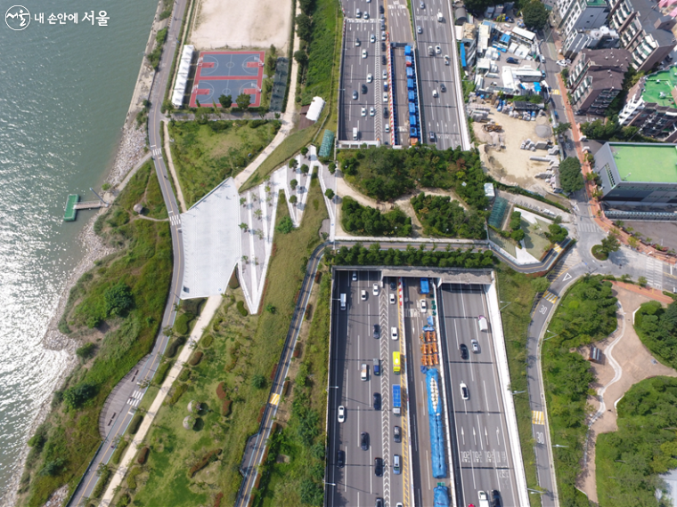
Amble down the bike path along the Han River. Baseball diamonds, tennis courts, and soccer pitches fade into a set of jagged concrete stairs that lead up to a 55-meter wide pedestrian overpass covered with green.
In 2014, Seoul demolished the dark, damp underground “rabbit hole” (토끼굴) or underpass let pedestrians cross under Gangbyeon Expressway from the Mangwon Neighborhood to the Han River. They replaced it with the more vibrant Mangwon Green Road (망원초록길; map; road view; picture), which holds a small pine forest, observation decks, and cycling and walking paths.
And it offers access to an epic detour into the Mapo District.
One Pavilion, Two Locales
Are you hungry? Interested in history? Shopping?!
Travel over Mangwon Green Road via stairs or cycling path (road view) and embark on a detour to three nearby highlights.
Shoved against the expressway, flanked by apartments, sits the 600-year-old Mangwon Pavilion (망원정터; map; road view).
King Sejong the Great (조선세종) built the pavilion for his brother in 1424. Sejong and his royal court frequented the pavilion, ate lunch, and watched naval exercises on the Han River.
King Sejong visited Mangwon Pavilion one day amidst a drought. As he arrived, the skies opened and rain poured. Locals renamed the pavilion “Hweeujeong” (희우정) or “Happy Rain Pavilion.”
Time and war destroyed many of Seoul’s river pavilions. But in 1989, the city decided Mangwon Pavilion was too important. They restored and designated it a cultural heritage site.
“Hongdae” is the truncated name of the local arts university:
Hongik (홍익)
Dāe-hak-gyō (대학교) or “University”
Locals once visited Hongdae for its indie-chic aurora. However, as Seoul’s fortunes multiplied, nightclubs, pricey eateries, and designer stores conquered the area.
Hongdae Street (홍대거리; map), swamped with sightseers and shoppers, is Seoul’s the third most traveled commercial street, behind Gangnam and Myeongdong.
Sinchon Neighborhood’s fountain of youths creates buzzing retail and nightlife zones filled with noraebangs (karaoke rooms), PC bangs, and sunrise-greeting clubs.
Yanghwa Bridge crosses the Han River and lands in Yanghwa Hangang Park. Midway down its span, the bridge glances off of Seonyu Island Park, an old water treatment plant converted into a sculpture park.
After Yanghwa Bridge, Mangwon Hangang Park’s green spaces zip shut. Gangbyeon Expressway splits apart and its eastbound lanes rise on concrete pylons, swerving over the cycling path and the Han River.
Jeoldu Mountain (절두산; map; Jeoldusan), that rocky outcrop overlooking the Han River, claims a second name: “beheading hill.”
In 1866, Joseon’s Regent Daewongun grew suspicious of Western Powers’ influence in Asia (see the Opium Wars). He ordered soldiers to round up all Catholic Missionaries and converts in Korea and bring them to Jeoldu Mountain. There, executioners decapitated over 8,000.
Today, Jeoldusan Martyrs’ Shrine peeks over the top of Jeoldu Mountain. It commemorates all of Korea’s Christian martyrs.
Cycle onward. Overhead, Gangbyeon Expressway’s east and westbound lanes flank the bike path.
Pause. Look out over the Han River. Discover two islands:
On your left sits Bamseom Island (밤섬; map). Once holding a small town, Seoul destroyed it in the ‘70s to improve the Han River’s flow and expand nearby Yeouido. Over the years, river silt rebuilt Bamseom. Now it’s an uninhabited ecological paradise.
Before continuing, glance at the shady area under the Gangbyeon Expressway. Amongst concrete pylons, find public exercise equipment and a freestanding elevator tower. Ride up it, hop a short bridge, and land in Mapo Saebit Culture Forest.
The area once held the Dangin-ri Power Plant (당인리 발전소). Built in 1930, it was Korea’s first power station, electrifying Seoul through the mid-20th century. But it was dirty, choking locals by burning coal, then heavy fuel oil.
In 1993, the plant switched to liquified natural gas (LNG) and changed its name to “Seoul Thermal Power Plant.” But residents still complained about the pollution.
The power company, Korea Midland Power, couldn’t find a suitable spot outside the city for a new power station. So they constructed the world’s first underground power plant.
Known as a “LNG combined cycle power plant,” this new facility produces 50% more electricity by cycling the same energy source twice. Here’s how it works:
The plant burns LNG in a gas turbine, generating electricity.
Excess heat is captured to make steam, which spins a second turbine, generating yet more electricity.
Korea Midland Power then built the Mapo Saebit Culture Forest above ground on the site of the old power plant. It hosts a park, the company’s headquarters, and, inside the retired generator buildings, the Danginri Creative Art Plant.
Three Bridges
Let’s continue our cycling trip.
Mangwon Hangang Park remaining 3.5 kilometers zoom under and around the Gangbyeon Expressway’s underbelly (directions), passing pocket parks smushed against embankments, and three bridges:
(An elevator on the bike path makes access to Seogang Bridge simple. But the bridge’s narrow sidewalks aren’t ideal for biking.)
Cycle onwards through gently winding paths. Pass benches covered with green canopies, a jokgu court (족구; hand & foot volleyball), and a sculpture of an ancient trading boat. The pedestal below the boat sculpture holds a map and history of the major river port villages around Seoul during the Joseon-era (1392 ~ 1897).
A kilometer past Seogang Bridge, swirling ramps merge onto Mapo Bridge (마포대교; map). Completed in 1970, it helped transform Yeouido Island into the “Manhattan of Korea” by increasing access from Seoul’s established northern districts.
Nicknamed the “Bridge of Life,” Mapo Bridge is infamous as Seoul’s most popular suicide bridge. Some believe, because of its proximity to Korea’s stock exchange on Yeouido, brokers fled to the bridge after having their margins called.
To prevent attempts, Seoul installed an inward curving, 2.5-meter tall railing topped with a free-spinning mechanism. While still an issue, suicide successes have fallen by half.
Ramps on the north end (road view) and south end (road view) of Mapo Bridge let riders quickly hop over the Han River between Mangwon and Yeouido Hangang Parks.
Yeouido Certification Center
Yeouido Certification Center sits along the bike path in front of the National Assembly Building in Yeouido Hangang Park.
The South Side only hits two-thirds of Seoul’s red booths. But its second stamp booth, Gwangnaru Bike Park, is interchangeable with the North Side’s Ttukseom Observatory stamp. One counts for the other. You don’t need to cross the river.
If you’re a stamp hunter and are riding the North side, you need to cross to the South Side and grab the Yeouido Certification Center stamp. It doesn’t have a North Side equivalent.
Mapo Bridge is the best crossing to collect the Yeouido stamp. Just jump the Han, stamp your Bike Passport, then pop back over the river. Total distance? 6.8 kilometers (30 minutes; directions). The reward? Certification glory!
Pedal under Mapo Bridge. A few hundred meters later, enter the Yongsan District, an ancient area below Joseon’s old capital, now the Jongno and Jung Districts.
Up ahead, follow the V-shaped pylons holding up Gangbyeon Expressway to Wonhyo Bridge (원효대교; map).
Glance at the culvert below the bridge (road view). The monster in Oscar-winning Bong Joon-ho’s 2006 film The Host hid out in this damp and dark concrete hole.
Wonhyo Bridge also marks the end of Mangwon Hangang Park and the start of Ichon Hangang Park.


